Schools out for the summer! This three-day adventure offers a wide range of urban and wilderness trails with accommodation from camping to what I call, “credit card and toothbrush” where one is guaranteed a shower to wash off the dust at the end of the day and a shelter complete with no assembly required.

Day 1 (80km 634m)
We parked the car at Tsawwassen’s Park and Go less than 5 kms from the ferry. Arriving in Swartz Bay it was 16C with overcast skies - a refreshing climate change from the heat dome we experienced earlier in the week. We rolled off the ferry and followed the signs for the Lochside Regional Trail,a 33.5 km paved and crushed gravel path that rolls into Victoria. We chose to exit left at the Blenkinsop Lake Trestle that took us to Cordova Bay via San Juan trail, hugging the edge of the land closest to the water around Oak Bay and James Bay. Stopping in front of Victoria’s parliament buildings, Canada Day looked very different this year; a colour change from red and white to orange offering us a time to reflect on the journey we will take toward reconciliation with Indigenous communities across Canada.
From downtown Victoria, we picked up the Galloping Goose Regional Trail and followed it to Langford, BC, our destination. Goldstream Provincial Park is a nearby campground.

Day 2 (80kms 953m)
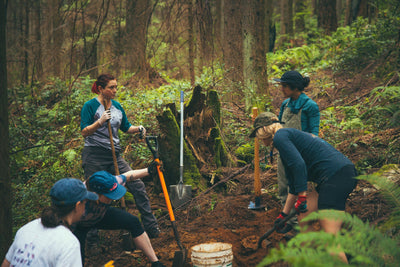
This is a pure gravel day, by far the most adventurous and fun part of the weekend. Out of Langford, we followed directions to the Humpback Trailhead at the south end of the Sooke Hills Wilderness Trail. This trail is 13 kms in length with a suspension bridge and challenging steep grades up to 16% over the Malahat. Oh and there are fun downhills to navigate too - just be mindful of the loose gravel around corners. The north end of this trail becomes The Great Trail, formerly known as the Trans Canada Trail. There is a crucial post marker (see photo) indicating the way for cyclists which is a different route than for hikers. This confused us solely because we did not take note of the post marker - doh! Cyclists follow a paved roadway for a short distance to Findlayson View Place, while hikers are guided up a narrow, single track trail. No hike-a-bike after all. From here, the Cowichan Valley Trail continues at the top of the Malahat, north to Shawnigan Lake, across the historic Kinsol Trestle, and west to the town of Lake Cowichan. We chose to stop at West Shawnigan Lake Provincial Park for a refreshing swim and of course, more food. There are well-maintained amenities along this route consisting of washrooms, portable toilets, and picnic areas.
The historic Kinsol Trestle is an impressive, timber rail structure, free-standing 44m above and 187m along the Koksilah River. It is one of eight trestles along the Cowichan Valley Trail route and by far is the most spectacular. At the 70.2 Mile Trestle, we noticed a footpath down to a pebble beach alongside the Cowichan River. We debated the effort to hike-a-bike down the path for a swim when we were so close to finishing the trail and arriving at our destination. As we were suspended like Superman by the fast-flowing water rushing across our bodies while we gripped our hands around large river rocks that kept us from being swept downstream, we wondered how we ever debated the decision.

Day 3 (83km 529m)
Out of Lake Cowichan, we followed the north side of the Cowichan Valley Trail for 27kms. As our Garmins hit close to 40km/hr on gravel bikes we believed it was the bacon, egg and generous amount of cheddar cheese omelette we ate for breakfast and not that this section of the rail trail slightly sloped downhill. Our cruising speed came to a halt as a sharp metal chard punchered my tire. It was during the change that we were reminded of the essentials we forgot to check: a faulty C02 inflator and the failed backup hand pump would have kept us there all morning if not saved by a man on an eBike with the proper tools. We finished the trail and used Google Maps to navigate back roads through Cowichan farmlands to the Brentwood Bay. The Mill Bay ferry crossing is a pleasant rest stop before using Google Maps once again to navigate to the Lochside trail that ends back at the Swartz Bay ferry to Tsawwassen.

Thank you to Stephanie Jansen for submitting this content!
Gear Recommendations
Apidura's Expedition Saddle pack available in 9L, 14L and 17L sizes is a robust and fully waterproof saddle bag attaching to the seat and seatpost that eliminates the need for a rear rack. Using a lightweight tear-resistant laminate with welded seams, the Expedition Saddle Pack will keep your personal belongings dry in the heaviest of downpours. With an HDPE molded section keeping the bag rigid and a roll-top to adapt the bag to your load size the Expedition pack is practical, versatile and hard wearing, perfect for those long trips.
Designed in England, the Brooks Scape Handlebar Pouch is a versatile bag for stowing those much-needed items, ideal for small day trips or as part of your setup for larger trips. With fully welded seams, waterproof materials, and classic looks the Scape Handlebar Pouch combines modern practicality with retro styling, and with Brooks' legendary build quality and top notch materials it'll go the distance too.